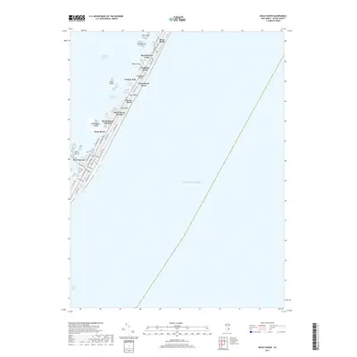
2019 Map of Beach Haven
USGS Topo · Published 2019About this map
Long Beach Island forms a narrow, developed barrier between the Atlantic Ocean and Little Egg Harbor in this 2019 survey of southern Ocean County. The residential and commercial density is concentrated along the central spine of Long Beach Blvd, connecting a series of established shore communities including Brant Beach, Beach Haven Crest, and Peahala Park. To the south, the grid-plan layout of Beach Haven reveals a detailed street network featuring Engleside Ave and Centre St, leading down toward the Beach Haven Inlet. The map highlights the aquatic geography of the Intracoastal Waterway and the various marshy landforms scattered throughout the harbor, such as Ham Island, Parker Island, and the Marshelder Islands. This modern topographic study serves as a contemporary record of coastal infrastructure, from the residential enclave of The Dunes to the marinas along Liberty Thorofare.
Find a feature on this map
45 named features on this map. Tap any name to fly to it.
Don’t see what you’re looking for? This feature index may not catch every label — zoom into the map to look around manually.
Map Details
Editions of this 2019 Beach Haven Map
This is the sole edition of this map. No revisions or reprints were ever made.
Other maps of this area

1887 · Atlantic City
USGS Topo · 1:62,500

1888 · Little Egg Harbor
USGS Topo · 1:62,500

1888 · Long Beach
USGS Topo · 1:62,500

1893 · Little Egg Harbor
USGS Topo · 1:62,500

1893 · Long Beach
USGS Topo · 1:62,500

1894 · Atlantic City
USGS Topo · 1:62,500

1919 · Long Beach
USGS Topo · 1:62,500

1920 · Little Egg Harbor
USGS Topo · 1:62,500

1940 · Atlantic City
USGS Topo · 1:62,500
1941 · Atlantic City
USGS Topo · 1:62,500