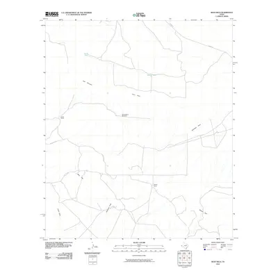
2010 Map of Bean Hills
USGS Topo · Published 2010About this map
Keene Ranch and Dullnig Ranch anchor this landscape in West Texas, where water management is central to the local geography. Scattered across the arid terrain are essential landmarks such as the Sand Hollow Windmill, South Tank, and Skinner Tank, representing the infrastructure required for ranching in this environment. The topography is defined by the Sierra Diablo and the rising elevations of Goat Mountain. Natural drainages like Seventeen Draw and Camel Draw cross the plains between the Bean Hills and Millican Hills, illustrating the watershed patterns that dictate land use in Hudspeth County. Access through this isolated territory is maintained via Garren Rd and Eagle Flat Rd, connecting these remote ranching outposts to the broader region.
Find a feature on this map
14 named features on this map. Tap any name to fly to it.
Don’t see what you’re looking for? This feature index may not catch every label — zoom into the map to look around manually.
Map Details
Editions of this 2010 Bean Hills Map
This is the sole edition of this map. No revisions or reprints were ever made.
Other maps of this area

1895 · Sierra Blanca
USGS Topo · 1:125,000

1906 · Van Horn
USGS Topo · 1:125,000

1954 · Van Horn
USGS Topo · 1:250,000

1958 · Van Horn
USGS Topo · 1:250,000
1963 · Grayton Lake
USGS Topo · 1:24,000
1964 · Hackett Peak
USGS Topo · 1:24,000
1964 · Allamoore
USGS Topo · 1:24,000
1964 · Sheep Peak
USGS Topo · 1:24,000

1964 · Dome Peak
USGS Topo · 1:24,000
1964 · Bean Hills
USGS Topo · 1:24,000