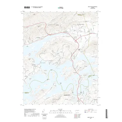
2019 Map of Bean Station
USGS Topo · Published 2019About this map
Cherokee Lake dominates the landscape of this region where Grainger, Hawkins, and Hamblen counties converge. The reservoir's reach is marked by several historical crossings and shoals, including German Shoals and Sheltons Shoals, which hint at the river's character before the creation of the dam. The settlement of Bean Station serves as a central hub, situated near the gap in Clinch Mountain and Poor Valley Ridge. Local genealogy is well-documented through numerous family burial sites such as Isenberg Cem, Caldwell Cem, and McDaniel Rd. Further south, the map details the industrial and residential fringes of Morristown, including the Lakemoore and Marguerite areas. The inclusion of Cloud 9 Aerodrome and the William P Harrell Bridge illustrates the modern infrastructure layered over the older agricultural valleys of Richland Valley and Mooresburg Valley.
Find a feature on this map
80 named features on this map. Tap any name to fly to it.
Don’t see what you’re looking for? This feature index may not catch every label — zoom into the map to look around manually.
Map Details
Editions of this 2019 Bean Station Map
This is the sole edition of this map. No revisions or reprints were ever made.
Other maps of this area

1883 · Morristown
USGS Topo · 1:125,000

1893 · Morristown
USGS Topo · 1:125,000

1895 · Morristown
USGS Topo · 1:125,000

1935 · Rogersville
USGS Topo · 1:48,000

1935 · Tate Springs
USGS Topo · 1:48,000

1935 · Lee Valley
USGS Topo · 1:24,000

1935 · Springvale
USGS Topo · 1:24,000

1935 · Howard Quarter
USGS Topo · 1:24,000

1935 · Swan Island
USGS Topo · 1:24,000

1935 · Avondale
USGS Topo · 1:24,000