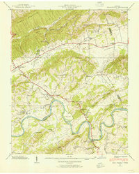
1938 Map of Bean Station
USGS Topo · Published 1954About this map
Tate Springs and the historic crossroads of Bean Station anchor this late 1930s landscape, where the Southern Railway and the intersection of the Lee Highway and Dixie Highway drove local commerce. The terrain is defined by the heavy ridges of Clinch Mountain and Boatman Mountain, which channel the Holston River through a series of dramatic bends. Along the river's path, islands such as Payne Island and Sycamore Island appear alongside industrial markers like the Morristown Municipal Power House and the Holston Bridge.
Find a feature on this map
76 named features on this map. Tap any name to fly to it.
Don’t see what you’re looking for? This feature index may not catch every label — zoom into the map to look around manually.
Map Details
Editions of this 1938 Bean Station Map
2 editions found
Other maps of this area

1883 · Morristown
USGS Topo · 1:125,000

1893 · Morristown
USGS Topo · 1:125,000

1895 · Morristown
USGS Topo · 1:125,000

1935 · Rogersville
USGS Topo · 1:48,000

1935 · Tate Springs
USGS Topo · 1:48,000

1935 · Lee Valley
USGS Topo · 1:24,000

1935 · Springvale
USGS Topo · 1:24,000

1935 · Howard Quarter
USGS Topo · 1:24,000

1935 · Swan Island
USGS Topo · 1:24,000

1935 · Avondale
USGS Topo · 1:24,000