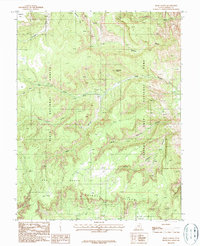
1987 Map of Bear Canyon
USGS Topo · Published 1987About this map
Capitol Reef National Park and Dixie National Forest converge in this high-desert canyon landscape, where the geological drama of the Circle Cliffs and Dry Bench dominates the terrain. This 1980s provisional map details a network of narrow drainages including Bear Canyon, Coleman Canyon, and the winding Tantalus Creek. The map records specific points of geological interest such as Natural Arches and Oak Creek Point, alongside several unnamed Prospect and Prospects sites that suggest mid-to-late 20th-century mineral exploration. Unlike many desert quadrangles, this area is defined by its deep forks and washes like Fivemile Wash and Maverick Draw, which serve as the primary conduits through the complex topography of the Waterpocket Fold region. The absence of permanent structures highlights the isolation of Jorgenson Flat during this era, with only primitive 4WD tracks providing access to these remote canyons.
Find a feature on this map
24 named features on this map. Tap any name to fly to it.
Don’t see what you’re looking for? This feature index may not catch every label — zoom into the map to look around manually.
Map Details
Editions of this 1987 Bear Canyon Map
This is the sole edition of this map. No revisions or reprints were ever made.
Other maps of this area

1885 · Fish Lake
USGS Topo · 1:250,000

1886 · Escalante
USGS Topo · 1:250,000

1896 · Fish Lake
USGS Topo · 1:250,000

1952 · Notom 4 SE
USGS Topo · 1:24,000

1952 · Notom 4 NW
USGS Topo · 1:24,000

1952 · Notom 4 SW
USGS Topo · 1:24,000

1952 · Notom 4 NE
USGS Topo · 1:24,000

1952 · Notom 3 SE
USGS Topo · 1:24,000

1952 · Notom 3 NE
USGS Topo · 1:24,000

1952 · Grover
USGS Topo · 1:62,500