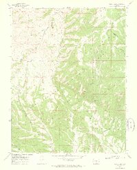
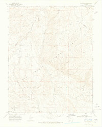
1969 Map of Bear Creek
USGS Topo · Published 1973About this map
San Isabel National Forest dominates this high-altitude landscape along the border of Custer and Huerfano counties, where the drainage systems of Bear Creek and its many tributaries carve through the eastern slopes of Greenhorn Mountain. The 1969 field survey captures a transition between the elevated peaks and the deep basin of Devils Hole, where Williams Creek and Reveille Creek converge. The human footprint is sparse, primarily confined to the winding Gardner Road and a network of specialized routes including the Horse Trail and Pack Trail. Small-scale resource exploration is evident in scattered prospects and a corral, suggesting a landscape utilized for seasonal grazing and prospecting. Numerous water sources like Blue Spring and Froze Creek provided vital points for early travelers moving through the high-country gaps.
Find a feature on this map
25 named features on this map. Tap any name to fly to it.
Don’t see what you’re looking for? This feature index may not catch every label — zoom into the map to look around manually.
Map Details
Editions of this 1969 Bear Creek Map
3 editions found

Other maps of this area

1889 · Canon City
USGS Topo · 1:125,000

1889 · Huerfano Park
USGS Topo · 1:125,000

1892 · Huerfano Park
USGS Topo · 1:125,000

1892 · Canon City
USGS Topo · 1:125,000

1954 · Rosita
USGS Topo · 1:24,000

1954 · Trinidad
USGS Topo · 1:250,000

1954 · Pueblo
USGS Topo · 1:250,000

1955 · Trinidad
USGS Topo · 1:250,000

1957 · Pueblo
USGS Topo · 1:250,000

1958 · Trinidad
USGS Topo · 1:250,000