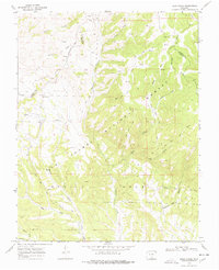
1969 Map of Bear Creek
USGS Topo · Published 1978About this map
Greenhorn Mountain and the eastern slopes of the Wet Mountains dominate this 1969 topographic survey, revealing a landscape defined by deep drainage basins and remote access. Much of the area is protected within the San Isabel National Forest, where the complex hydrology of the North Fork and South Fork of the Bear Creek drainage systems is meticulously mapped. The presence of Prospects north of Sheep Mountain suggests early mineral exploration in these high-altitude canyons.
Find a feature on this map
31 named features on this map. Tap any name to fly to it.
Don’t see what you’re looking for? This feature index may not catch every label — zoom into the map to look around manually.
Map Details
Editions of this 1969 Bear Creek Map
3 editions found
Other maps of this area

1889 · Canon City
USGS Topo · 1:125,000

1889 · Huerfano Park
USGS Topo · 1:125,000

1892 · Huerfano Park
USGS Topo · 1:125,000

1892 · Canon City
USGS Topo · 1:125,000

1954 · Rosita
USGS Topo · 1:24,000

1954 · Trinidad
USGS Topo · 1:250,000

1954 · Pueblo
USGS Topo · 1:250,000

1955 · Trinidad
USGS Topo · 1:250,000

1957 · Pueblo
USGS Topo · 1:250,000

1958 · Trinidad
USGS Topo · 1:250,000