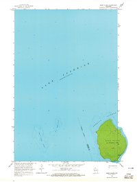
1963 Map of Bear Island
USGS Topo · Published 1965About this map
Bear Island dominates this mid-century survey of the northern reaches of the Apostle Islands in Lake Superior. The topography is defined by the steep elevation changes of the island's interior, contrasted against the expansive waters that separate it from nearby landmasses. Within the jurisdiction of La Pointe Twp, the island's perimeter is traced by simple trails, suggesting a landscape largely defined by wilderness or limited seasonal access rather than permanent development.
Find a feature on this map
9 named features on this map. Tap any name to fly to it.
Don’t see what you’re looking for? This feature index may not catch every label — zoom into the map to look around manually.
Map Details
Editions of this 1963 Bear Island Map
This is the sole edition of this map. No revisions or reprints were ever made.
Other maps of this area

1941 · Bayfield
USGS Topo · 1:48,000

1946 · Bayfield
USGS Topo · 1:48,000

1953 · Ashland
USGS Topo · 1:250,000

1954 · Two Harbors
USGS Topo · 1:250,000

1957 · Two Harbors
USGS Topo · 1:250,000

1958 · Ashland
USGS Topo · 1:250,000

1958 · Two Harbors
USGS Topo · 1:250,000

1963 · Rocky Island
USGS Topo · 1:62,500

1963 · Oak Island
USGS Topo · 1:24,000
1963 · Rocky Island
USGS Topo · 1:24,000