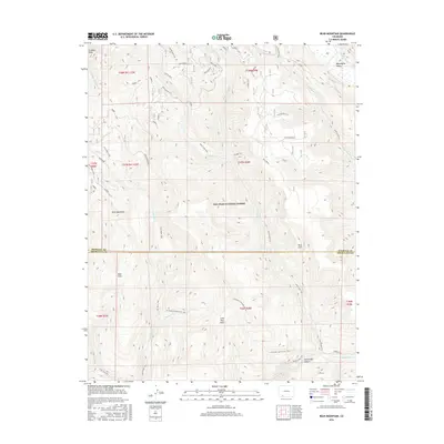
2016 Map of Bear Mountain
USGS Topo · Published 2016About this map
Graham Peak and Bear Mountain dominate this high-altitude landscape within the San Juan National Forest, where the terrain is defined by its drainage systems and pack trails. The map documents a complex network of watercourses including Coldwater Creek and Sand Creek, which flow through high meadows like Bear Park and Lone Tree Park. A significant geographical boundary between Hinsdale and Archuleta counties bisects the region, reflecting the administrative divisions in this undeveloped forest interior. The southern portion of the sheet is marked by the path of the Piedra River as it passes near the Second Box Canyon. Long-established routes such as the Sand Creek Trail and the Coldwater Stock Drive Trail illustrate the historical reliance on traditional paths for moving livestock and navigating the wilderness before modern road development reached these elevations.
Find a feature on this map
31 named features on this map. Tap any name to fly to it.
Don’t see what you’re looking for? This feature index may not catch every label — zoom into the map to look around manually.
Map Details
Editions of this 2016 Bear Mountain Map
This is the sole edition of this map. No revisions or reprints were ever made.
Other maps of this area

1905 · San Cristobal
USGS Topo · 1:125,000

1907 · San Cristobal
USGS Topo · 1:125,000

1924 · Pagosa Springs
USGS Topo · 1:125,000

1927 · Pagosa Springs
USGS Topo · 1:125,000

1945 · Durango
USGS Topo · 1:250,000

1953 · Durango
USGS Topo · 1:250,000

1954 · Durango
USGS Topo · 1:250,000

1961 · Durango
USGS Topo · 1:250,000

1963 · Durango
USGS Topo · 1:250,000
1964 · Chris Mountain
USGS Topo · 1:24,000