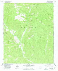
1977 Map of Bear Ridge
USGS Topo · Published 1978About this map
Fort Apache Indian Reservation encompasses this high-elevation landscape, where the drainage systems of Carrizo Creek and Deer Springs carve through complex canyon terrain. The map reflects a period of intensive land management by the Bureau of Indian Affairs, documenting a network of historic transportation routes including the Rim Road and numerous segments of Pack Trail and Jeep Trail that traverse the ridges. Local landmarks such as Scott Cabin provide rare evidence of fixed habitation in this remote region. The topography is defined by prominent features like Bear Ridge and Cibecue Ridge, which separate distinct drainages such as Honeymoon Canyon and Blackie Trap Canyon. These labels suggest a landscape historically utilized for livestock and seasonal movement, supported by scattered water sources like Black Bear Spring and Jumpoff Spring.
Find a feature on this map
23 named features on this map. Tap any name to fly to it.
Don’t see what you’re looking for? This feature index may not catch every label — zoom into the map to look around manually.
Map Details
Editions of this 1977 Bear Ridge Map
This is the sole edition of this map. No revisions or reprints were ever made.
Other maps of this area

1886 · Holbrook
USGS Topo · 1:250,000

1893 · Holbrook
USGS Topo · 1:250,000

1954 · Holbrook
USGS Topo · 1:250,000

1957 · Holbrook
USGS Topo · 1:250,000

1958 · Holbrook
USGS Topo · 1:250,000

1960 · Holbrook
USGS Topo · 1:250,000

1961 · Clay Springs
USGS Topo · 1:62,500

1961 · Heber
USGS Topo · 1:62,500

1961 · Cibecue
USGS Topo · 1:62,500

1961 · Chediski Peak
USGS Topo · 1:62,500