
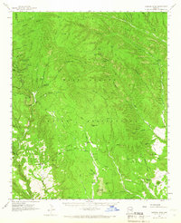
1961 Map of Chediski Peak
USGS Topo · Published 1963About this map
The Fort Apache Indian Reservation landscape is defined by its high timbered ridges and deep canyon systems in the early 1960s. High points such as Chediski Peak and Chediski Mountain rise above a network of jeep trails and remote lookouts, including the Chediski Peak Lookout. The map captures a moment when land use was centered on the cattle economy and resource management, evidenced by the numerous named stock tanks and cattle infrastructure like Salt Creek Tank and Double Tank.
Find a feature on this map
68 named features on this map. Tap any name to fly to it.
Don’t see what you’re looking for? This feature index may not catch every label — zoom into the map to look around manually.
Map Details
Editions of this 1961 Chediski Peak Map
2 editions found
Other maps of this area

1886 · Holbrook
USGS Topo · 1:250,000

1893 · Holbrook
USGS Topo · 1:250,000

1922 · Chrysotile
USGS Topo · 1:125,000

1946 · Blue House Mtn
USGS Topo · 1:62,500

1949 · McFadden Peak
USGS Topo · 1:62,500

1950 · McFadden Peak
USGS Topo · 1:62,500

1951 · Blue House Mtn
USGS Topo · 1:62,500

1954 · Holbrook
USGS Topo · 1:250,000

1954 · Mesa
USGS Topo · 1:250,000

1957 · Mesa
USGS Topo · 1:250,000