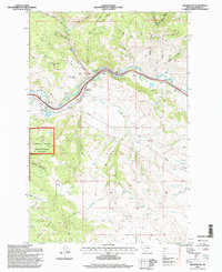
1996 Map of Bearmouth
USGS Topo · Published 1998About this map
Clark Fork cuts a deep path through this corner of Granite County, where industrial activity and mountain terrain converge. This 1996 survey highlights the area's mining history, specifically near the Bearmouth Prospect and scattered prospects along the river's edge. The landscape is heavily marked by the extraction of resources, including a large area of Tailings and a Gravel Pit located near the river bend.
Find a feature on this map
25 named features on this map. Tap any name to fly to it.
Don’t see what you’re looking for? This feature index may not catch every label — zoom into the map to look around manually.
Map Details
Editions of this 1996 Bearmouth Map
This is the sole edition of this map. No revisions or reprints were ever made.
Other maps of this area

1919 · Drummond
USGS Topo · 1:125,000

1921 · Drummond
USGS Topo · 1:125,000

1947 · Butte
USGS Topo · 1:250,000

1958 · Butte
USGS Topo · 1:250,000

1958 · Drummond
USGS Topo · 1:62,500

1959 · Bearmouth
USGS Topo · 1:62,500

1960 · Butte
USGS Topo · 1:250,000

1962 · Butte
USGS Topo · 1:250,000

1965 · Union Peak
USGS Topo · 1:24,000

1965 · Wild Horse Parks
USGS Topo · 1:24,000