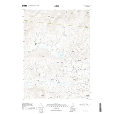
2019 Map of Bearsville
USGS Topo · Published 2019About this map
Byrdcliffe and the surrounding hamlets north of Woodstock occupy a landscape defined by the steep southern Catskill peaks. This 2019 survey captures the modern road network and preserved lands that have shaped the region since the late 19th century. High-elevation peaks such as Mt Tobias and Roundtop Mtn dominate the center of the sheet, forcing development into the narrow valleys where the Beaver Kill and Saw Kill flow. The map clearly illustrates the importance of water management in the area, centered on the significant footprint of Cooper Lake and the marshlands of Yankeetown Pond. Local history is anchored in distinct settlements like Bearsville, Shady, and Wittenberg, while recreation is centered on the Kenneth Wilson Campground. The northern border with Greene County follows a series of high ridges, including Little Rocky Mtn and Olderbark Mtn.
Find a feature on this map
109 named features on this map. Tap any name to fly to it.
Don’t see what you’re looking for? This feature index may not catch every label — zoom into the map to look around manually.
Map Details
Editions of this 2019 Bearsville Map
This is the sole edition of this map. No revisions or reprints were ever made.
Other maps of this area

1892 · Kaaterskill
USGS Topo · 1:62,500

1893 · Kaaterskill
USGS Topo · 1:62,500

1894 · Kaaterskill
USGS Topo · 1:62,500

1899 · Kaaterskill
USGS Topo · 1:62,500

1900 · Phoenicia
USGS Topo · 1:62,500

1901 · Rosendale
USGS Topo · 1:62,500

1903 · Rosendale
USGS Topo · 1:62,500

1903 · Phoenicia
USGS Topo · 1:62,500

1903 · Kaaterskill
USGS Topo · 1:62,500

1903 · Slide Mountain
USGS Topo · 1:62,500