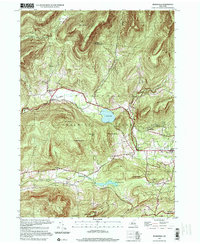
1997 Map of Bearsville
USGS Topo · Published 2001About this map
Catskill Park dominates this landscape, where the town of Woodstock and the hamlet of Bearsville sit at the feet of the high peaks. The 1997 photoinspection, reflecting imagery back to 1943, reveals a rugged terrain defined by the drainage of the Saw Kill and Beaver Kill. Cultural history is anchored by early educational sites like School No 5 near Lake Hill and School No 3 south of Bearsville. The map highlights the historic arts-and-crafts colony at Byrdcliffe, situated on the slopes of Guardian Mountain. This region, long a retreat for artists and naturalists, maintains a settlement pattern of small clusters like Willow and Shady connected by Route 212, while the high elevations of Overlook Mountain and Mt Tobias remain largely undeveloped and protected.
Find a feature on this map
41 named features on this map. Tap any name to fly to it.
Don’t see what you’re looking for? This feature index may not catch every label — zoom into the map to look around manually.
Map Details
Editions of this 1997 Bearsville Map
This is the sole edition of this map. No revisions or reprints were ever made.
Other maps of this area

1892 · Kaaterskill
USGS Topo · 1:62,500

1893 · Kaaterskill
USGS Topo · 1:62,500

1894 · Kaaterskill
USGS Topo · 1:62,500

1899 · Kaaterskill
USGS Topo · 1:62,500

1900 · Phoenicia
USGS Topo · 1:62,500

1901 · Rosendale
USGS Topo · 1:62,500

1903 · Rosendale
USGS Topo · 1:62,500

1903 · Phoenicia
USGS Topo · 1:62,500

1903 · Kaaterskill
USGS Topo · 1:62,500

1903 · Slide Mountain
USGS Topo · 1:62,500