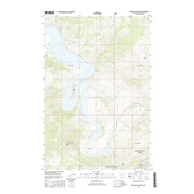
2017 Map of Beartooth Mountain
USGS Topo · Published 2017About this map
Holter Lake dominates this segment of the Missouri River canyon, its waters winding through a dramatic landscape of deep gulches and steep ridgelines. The western portion of the Helena National Forest covers much of the terrain, where landmarks like Jackson Peak and Beartooth Mountain rise above the river valley. The topography here is marked by significant vertical relief, evidenced by the sharp descent from the highlands into Falls Gulch and Log Gulch.
Find a feature on this map
23 named features on this map. Tap any name to fly to it.
Don’t see what you’re looking for? This feature index may not catch every label — zoom into the map to look around manually.
Map Details
Editions of this 2017 Beartooth Mountain Map
This is the sole edition of this map. No revisions or reprints were ever made.
Other maps of this area

1886 · Great Falls
USGS Topo · 1:250,000

1886 · Fort Logan
USGS Topo · 1:250,000

1889 · Helena
USGS Topo · 1:250,000

1893 · Helena
USGS Topo · 1:250,000

1899 · Helena
USGS Topo · 1:250,000

1903 · Helena
USGS Topo · 1:250,000

1943 · Hogan
USGS Topo · 1:125,000

1947 · Butte
USGS Topo · 1:250,000

1948 · White Sulphur Springs
USGS Topo · 1:250,000

1954 · Great Falls
USGS Topo · 1:250,000