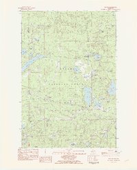
1982 Map of Beaton
USGS Topo · Published 1983About this map
The Ottawa National Forest dominates this northern Michigan landscape, where the legacy of the timber industry is visible in an Old Railroad Grade cutting through the dense lake country. Situated near the border of Marenisco and Watersmeet, this region is defined by a dense network of glacial water bodies and seasonal drainages. Small settlements like Beaton and Ogima serve as local anchors along the east-west corridor, which is also traversed by a significant Pipeline.
Find a feature on this map
52 named features on this map. Tap any name to fly to it.
Don’t see what you’re looking for? This feature index may not catch every label — zoom into the map to look around manually.
Map Details
Editions of this 1982 Beaton Map
2 editions found
Other maps of this area

1938 · Phelps
USGS Topo · 1:48,000

1946 · Star Lake
USGS Topo · 1:48,000

1950 · Phelps
USGS Topo · 1:48,000

1950 · Star Lake
USGS Topo · 1:48,000

1952 · Watersmeet
USGS Topo · 1:62,500

1952 · Thayer
USGS Topo · 1:62,500

1955 · Starlake
USGS Topo · 1:62,500

1956 · Phelps
USGS Topo · 1:62,500

1958 · Iron River
USGS Topo · 1:250,000

1960 · Iron River
USGS Topo · 1:250,000