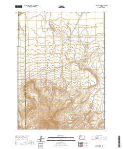
2020 Map of Beatys Butte
USGS Topo · Published 2020About this map
Beatys Butte towers over the high desert of Harney County, serving as the geographic anchor for this isolated expanse. The landscape is defined by its seasonal hydrology, where numerous named water sources such as Willow Spring, Buena Vista Spring, and Mustang Spring are critical markers across the arid terrain. Historical transit is etched into the earth via the Old Military Rd and Beatys Butte Rd, which bypass prominent landmarks like Rattlesnake Butte and the Red Hills. The northern portion of the map transitions into the Catlow Valley, while the southern reaches are dominated by the volcanic forms of Blocks Canyon and the Mustang Basin. This modern survey illustrates the enduring importance of reliable water sources and established trails in a region where the topography dictates movement and survival.
Find a feature on this map
27 named features on this map. Tap any name to fly to it.
Don’t see what you’re looking for? This feature index may not catch every label — zoom into the map to look around manually.
Map Details
Editions of this 2020 Beatys Butte Map
This is the sole edition of this map. No revisions or reprints were ever made.
Other maps of this area

1955 · Adel
USGS Topo · 1:250,000

1957 · Adel
USGS Topo · 1:250,000

1958 · Adel
USGS Topo · 1:250,000

1962 · Adel
USGS Topo · 1:250,000

1971 · Fish Fin Rim
USGS Topo · 1:24,000

1971 · Beatys Butte
USGS Topo · 1:24,000

1971 · Surveyors Lake
USGS Topo · 1:24,000

1971 · Mahogany Butte
USGS Topo · 1:24,000

1971 · Murphy Waterholes
USGS Topo · 1:24,000
1971 · Guano Reservoir
USGS Topo · 1:24,000