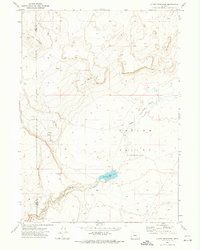
1971 Map of Guano Reservoir
USGS Topo · Published 1974About this map
Catlow Valley dominates this high desert landscape, characterized by a vast basin of internal drainage along the border of Lake and Harney Counties. At its center lies Guano Reservoir, a vital water source in this arid region, fed by the seasonal drainage of Guano Slough. The topographic survey, based on 1969 photography, reveals a terrain shaped by gradual elevations and depressions rather than sharp peaks, though landmarks like Cox Butte and the winding descent of Black Canyon provide distinct navigational points. Human activity is sparsely recorded, represented primarily by infrastructure like Borrow Pits and a solitary Spring. This map illustrates the intersection of natural hydrology and land management in the Oregon backcountry during the early 1970s, marking the exact county line between Lake and Harney as it traverses the desert floor.
Find a feature on this map
8 named features on this map. Tap any name to fly to it.
Don’t see what you’re looking for? This feature index may not catch every label — zoom into the map to look around manually.
Map Details
Editions of this 1971 Guano Reservoir Map
This is the sole edition of this map. No revisions or reprints were ever made.
Other maps of this area

1955 · Adel
USGS Topo · 1:250,000

1957 · Adel
USGS Topo · 1:250,000

1958 · Adel
USGS Topo · 1:250,000

1962 · Adel
USGS Topo · 1:250,000

1971 · Fish Fin Rim
USGS Topo · 1:24,000

1971 · Beatys Butte
USGS Topo · 1:24,000

1971 · Murphy Waterholes
USGS Topo · 1:24,000
1971 · Sixmile Draw
USGS Topo · 1:24,000
1971 · Blitzen SW
USGS Topo · 1:24,000
1971 · Beatys Butte NW
USGS Topo · 1:24,000