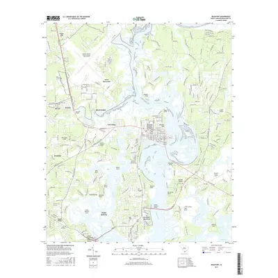
2017 Map of Beaufort
USGS Topo · Published 2017About this map
The complex tidal geography of the South Carolina Lowcountry is recorded here, where the Beaufort River and Brickyard Cr wind through a landscape defined by prominent points and marshy islands. This survey captures the strategic importance of the region, featuring major military installations like MCAS Beaufort and the northern edge of MCRD Beaufort Parris Island. The historic core of Beaufort is clearly delineated, showing the street grid near Barnwell Bluff and the sprawling Beaufort National Cemetery. Across the McTeer Memorial Bridge, the map tracks the development of Ladys Island and residential clusters such as Polk Village and Burton. Notable medical and educational institutions, including Navhosp Beaufort and the Technical Coll of the Lowcountry, underscore the area's role as a regional hub. Significant genealogical resources are documented through numerous burial sites, including Evergreen Cem, Bethlehem Cem, and Old Fort Cem.
Find a feature on this map
57 named features on this map. Tap any name to fly to it.
Don’t see what you’re looking for? This feature index may not catch every label — zoom into the map to look around manually.
Map Details
Editions of this 2017 Beaufort Map
This is the sole edition of this map. No revisions or reprints were ever made.
Other maps of this area

1918 · Green Pond
USGS Topo · 1:62,500

1918 · Yemassee
USGS Topo · 1:62,500

1920 · Okatie
USGS Topo · 1:62,500

1942 · Okatie
USGS Topo · 1:62,500

1943 · Yemassee
USGS Topo · 1:62,500

1943 · Green Pond
USGS Topo · 1:62,500

1944 · Fort Fremont
USGS Topo · 1:62,500

1947 · Savannah
USGS Topo · 1:250,000

1948 · Savannah
USGS Topo · 1:250,000

1956 · Frogmore
USGS Topo · 1:24,000