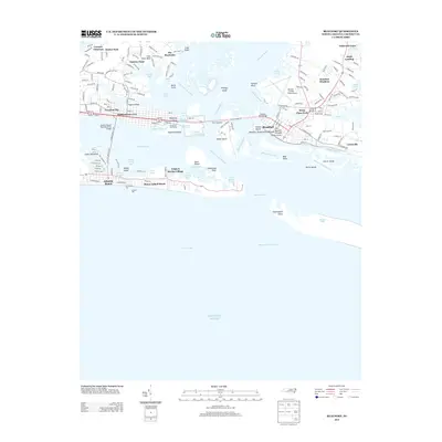
2013 Map of Beaufort
USGS Topo · Published 2013About this map
Morehead City and Beaufort stand as the primary coastal hubs on this 2013 survey of the North Carolina Inner Banks. The landscape is defined by its intricate marine geography, where the Newport River and Beaufort Channel meet the Atlantic Ocean at Beaufort Inlet. Local heritage is anchored by the Old Burying Grounds and Beaufort Restoration Grounds in the historic town center. The map reveals the critical infrastructure supporting this maritime economy, from the N C State Port Authority and Morehead Gulf Docks to the Michael J. Smith Field Airport. Further south, the barrier island communities of Atlantic Beach and Money Island Beach are shown with their landmark Sportsmans Pier and Oceana Pier, illustrating the region's long-standing connection to both commercial shipping and coastal recreation. Uninhabited areas like Carrot Island and Shackleford Point provide a view of the preserved natural shoreline across the Carrot Island Channel.
Find a feature on this map
144 named features on this map. Tap any name to fly to it.
Don’t see what you’re looking for? This feature index may not catch every label — zoom into the map to look around manually.
Map Details
Editions of this 2013 Beaufort Map
This is the sole edition of this map. No revisions or reprints were ever made.
Other maps of this area

1949 · Beaufort
USGS Topo · 1:24,000

1949 · Newport
USGS Topo · 1:24,000

1949 · Williston
USGS Topo · 1:24,000

1949 · Harkers Island
USGS Topo · 1:24,000

1949 · Mansfield
USGS Topo · 1:24,000

1949 · Core Creek
USGS Topo · 1:24,000

1951 · Williston
USGS Topo · 1:24,000

1951 · Newport
USGS Topo · 1:24,000

1951 · Core Creek
USGS Topo · 1:24,000
1951 · Peltier Creek
USGS Topo · 1:24,000