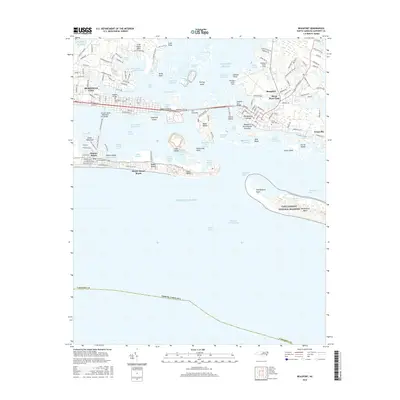
2016 Map of Beaufort
USGS Topo · Published 2016About this map
Beaufort and Morehead City anchor this coastal landscape, connected by The Causeway and Radio Island across the waters of Bogue Sound. The layout of Beaufort reveals its deep roots with the Old Burying Grounds and the Beaufort Restoration Grounds set among established street grids, while across the channel, Steep Pines Fork and Lenoxville mark the eastward residential extent. The maritime character of the area is defined by a complex network of channels and shoals, including Gallants Channel and the Beaufort Inlet.
Find a feature on this map
153 named features on this map. Tap any name to fly to it.
Don’t see what you’re looking for? This feature index may not catch every label — zoom into the map to look around manually.
Map Details
Editions of this 2016 Beaufort Map
This is the sole edition of this map. No revisions or reprints were ever made.
Other maps of this area

1949 · Beaufort
USGS Topo · 1:24,000

1949 · Newport
USGS Topo · 1:24,000

1949 · Williston
USGS Topo · 1:24,000

1949 · Harkers Island
USGS Topo · 1:24,000

1949 · Mansfield
USGS Topo · 1:24,000

1949 · Core Creek
USGS Topo · 1:24,000

1951 · Williston
USGS Topo · 1:24,000

1951 · Newport
USGS Topo · 1:24,000

1951 · Core Creek
USGS Topo · 1:24,000
1951 · Peltier Creek
USGS Topo · 1:24,000