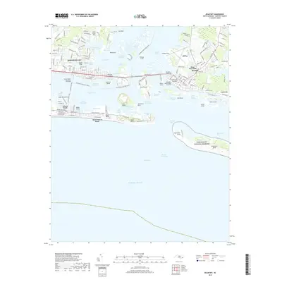
2019 Map of Beaufort
USGS Topo · Published 2019About this map
The coastal waters of Bogue Sound and Onslow Bay dominate this modern survey, capturing the complex maritime geography of the Outer Banks near the turn of the decade. The historic waterfronts of Morehead City and Beaufort are connected by The Causeway and Radio Island, illustrating the modern infrastructure required to bridge these inlet-divided communities. Significant cultural sites are preserved on the landscape, including the Old Burying Grounds in Beaufort and the sprawling expanse of Cape Lookout National Seashore on the Shackleford Banks. The map reveals the intricate network of channels and sloughs, such as Money Island Slough and Crab Point Thorofare, that define local navigation. From the residential streets of Steep Pines Fork to the aviation facilities at Michael J Smith Field, the survey provides a detailed account of Carteret County's modern development and shoreline character.
Find a feature on this map
144 named features on this map. Tap any name to fly to it.
Don’t see what you’re looking for? This feature index may not catch every label — zoom into the map to look around manually.
Map Details
Editions of this 2019 Beaufort Map
This is the sole edition of this map. No revisions or reprints were ever made.
Other maps of this area

1949 · Beaufort
USGS Topo · 1:24,000

1949 · Newport
USGS Topo · 1:24,000

1949 · Williston
USGS Topo · 1:24,000

1949 · Harkers Island
USGS Topo · 1:24,000

1949 · Mansfield
USGS Topo · 1:24,000

1949 · Core Creek
USGS Topo · 1:24,000

1951 · Williston
USGS Topo · 1:24,000

1951 · Newport
USGS Topo · 1:24,000

1951 · Core Creek
USGS Topo · 1:24,000
1951 · Peltier Creek
USGS Topo · 1:24,000