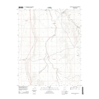
2014 Map of Beautiful Valley Well
USGS Topo · Published 2014About this map
Beautiful Valley dominates this high-desert landscape within the Navajo Nation, where the arterial Us-191 cuts a straight north-south line through the arid terrain. The settlement of Nazlini sits near the eastern edge, positioned at a point where the drainage of Nazlini Creek meets the local road network of Bia-26 and Bia-27. This map documents a region where water management is central to the land's utility, marked by the eponymous Beautiful Valley Well and the Flat Rock Reservoir near Cottonwood Canyon. The intricate drainage system is clearly defined by several named ephemeral watercourses, including Nazlini Wash, Bis-li-Ah Wash, and Tah-alth-cheed Wash. These labels reveal a geography where natural landforms and modern Bureau of Indian Affairs infrastructure intersect, reflecting the 21st-century character of this Chinle Agency territory.
Find a feature on this map
20 named features on this map. Tap any name to fly to it.
Don’t see what you’re looking for? This feature index may not catch every label — zoom into the map to look around manually.
Map Details
Editions of this 2014 Beautiful Valley Well Map
This is the sole edition of this map. No revisions or reprints were ever made.
Other maps of this area

1886 · Fort Defiance
USGS Topo · 1:250,000

1892 · Fort Defiance
USGS Topo · 1:250,000

1892 · Canyon De Chelly
USGS Topo · 1:250,000

1954 · Shiprock
USGS Topo · 1:250,000

1954 · Gallup
USGS Topo · 1:250,000

1955 · Zith-Tusayan Butte 2 SW
USGS Topo · 1:24,000

1955 · Zith-Tusayan Butte 2 NW
USGS Topo · 1:24,000

1955 · Chinle 4 SE
USGS Topo · 1:24,000
1955 · Sonsala Butte 3 SW
USGS Topo · 1:24,000
1955 · Canyon Del Muerto
USGS Topo · 1:62,500