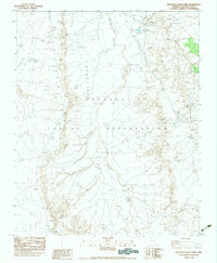
1983 Map of Beautiful Valley Well
USGS Topo · Published 1983About this map
The Navajo Indian Reservation landscape documented here is a complex network of seasonal drainage and vital water points in the high desert. Beautiful Valley dominates the central portion of the sheet, where the Bis ti ah Wash and Nazlini Wash converge in a wide, alluvial basin. The mapping reflects the essential infrastructure of a pastoral economy, specifically identifying remote resources like the Beautiful Valley Well and a Water Well situated near the head of Cottonwood Canyon Wash. This 1983 edition, compiled from earlier aerial photographs and field checks, provides a precise record of hydrologic features and terrain markers like Flat Rock and the Flat Rock Reservoir. The intricate labeling of numerous smaller washes, including Tah-ah-cheed Wash and Sand Wash, underscores the importance of every ephemeral watercourse in this arid region of Apache County.
Find a feature on this map
13 named features on this map. Tap any name to fly to it.
Don’t see what you’re looking for? This feature index may not catch every label — zoom into the map to look around manually.
Map Details
Editions of this 1983 Beautiful Valley Well Map
This is the sole edition of this map. No revisions or reprints were ever made.
Other maps of this area

1886 · Fort Defiance
USGS Topo · 1:250,000

1892 · Fort Defiance
USGS Topo · 1:250,000

1892 · Canyon De Chelly
USGS Topo · 1:250,000

1954 · Shiprock
USGS Topo · 1:250,000

1954 · Gallup
USGS Topo · 1:250,000

1955 · Zith-Tusayan Butte 2 SW
USGS Topo · 1:24,000

1955 · Zith-Tusayan Butte 2 NW
USGS Topo · 1:24,000

1955 · Chinle 4 SE
USGS Topo · 1:24,000
1955 · Sonsala Butte 3 SW
USGS Topo · 1:24,000
1955 · Canyon Del Muerto
USGS Topo · 1:62,500