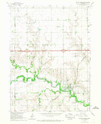
1966 Map of Beaver Crossing
USGS Topo · Published 1967About this map
The Beaver Crossing settlement dominates the southeastern landscape of this mid-1960s survey, positioned where the Chicago and North Western railroad corridor meets the winding path of the West Fork Big Blue River. The terrain is defined by the sharp transition between the level agricultural uplands and the deeply carved riparian valleys of Beaver Creek and Indian Creek. This intersection of rail and river commerce is underscored by the presence of several community landmarks, including the Calvary Cem and the municipal Sewage Disposal Pond.
Find a feature on this map
20 named features on this map. Tap any name to fly to it.
Don’t see what you’re looking for? This feature index may not catch every label — zoom into the map to look around manually.
Map Details
Editions of this 1966 Beaver Crossing Map
This is the sole edition of this map. No revisions or reprints were ever made.
Other maps of this area

1934 · Seward
USGS Topo · 1:48,000

1934 · Utica
USGS Topo · 1:62,500

1935 · Dorchester
USGS Topo · 1:48,000

1937 · Utica
USGS Topo · 1:62,500

1939 · Seward
USGS Topo · 1:62,500

1940 · Dorchester
USGS Topo · 1:62,500

1955 · Lincoln
USGS Topo · 1:250,000

1957 · Lincoln
USGS Topo · 1:250,000

1958 · Lincoln
USGS Topo · 1:250,000
1964 · Staplehurst
USGS Topo · 1:24,000