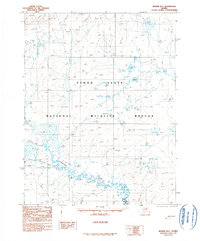
1990 Map of Beaver D-1
USGS Topo · Published 1990About this map
Yukon Flats dominate this subarctic landscape, characterized by an intricate network of wetlands and wandering watercourses within the Yukon Flats National Wildlife Refuge. The hydrology is defined by the meandering Hadweenzic River and its numerous tributaries, including Fortytwo Mile Creek, Forty and One-half Mile Creek, and Fortymile Creek. These waterways create a complex mosaic of ponds and marshland typical of the interior Alaskan basin. Human presence is sparse and strictly functional, marked by the Thirtysix Mile Cabin and a designated Winter Trail that provides seasonal passage across the drainage of Thirtytwo Mile Creek. This provisional map captures the region's wilderness character and the vital role of the river systems before more contemporary environmental shifts impacted the floodplains.
Find a feature on this map
13 named features on this map. Tap any name to fly to it.
Don’t see what you’re looking for? This feature index may not catch every label — zoom into the map to look around manually.
Map Details
Editions of this 1990 Beaver D-1 Map
This is the sole edition of this map. No revisions or reprints were ever made.
Other maps of this area

1951 · Fort Yukon
USGS Topo · 1:250,000

1951 · Chandalar
USGS Topo · 1:250,000

1951 · Christian
USGS Topo · 1:250,000

1951 · Beaver
USGS Topo · 1:250,000

1956 · Chandalar
USGS Topo · 1:250,000

1956 · Beaver
USGS Topo · 1:250,000

1956 · Christian
USGS Topo · 1:250,000

1956 · Fort Yukon
USGS Topo · 1:250,000
1956 · Fort Yukon D-6
USGS Topo · 1:63,360
1956 · Fort Yukon C-6
USGS Topo · 1:63,360