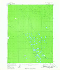
1956 Map of Fort Yukon D-6
USGS Topo · Published 1965About this map
The interior wilderness of Alaska, mapped during the mid-1950s, reveals a complex network of wetlands and isolated water bodies north of the Arctic Circle. The landscape is defined by its low-lying marshes and the absence of established roads or settlements, as seen in the remote drainage patterns of the Vunlui Lake and Vunzik Lake systems. These features characterize the interior Yukon region as it appeared before modern development, showcasing an environment shaped entirely by its hydrology. Further south, smaller landmarks like Sardine Can Lake and Cache Lake appear amidst a cluster of unnamed ponds and marshes. This survey, based on 1955 aerial photography, provides a record of the unsurveyed and unmarked land lines that dominated the territory just before Alaskan statehood.
Find a feature on this map
7 named features on this map. Tap any name to fly to it.
Don’t see what you’re looking for? This feature index may not catch every label — zoom into the map to look around manually.
Map Details
Editions of this 1956 Fort Yukon D-6 Map
2 editions found
Other maps of this area

1951 · Fort Yukon
USGS Topo · 1:250,000

1951 · Chandalar
USGS Topo · 1:250,000

1951 · Christian
USGS Topo · 1:250,000

1951 · Beaver
USGS Topo · 1:250,000

1955 · Fort Yukon D-5
USGS Topo · 1:63,360

1955 · Fort Yukon C-5
USGS Topo · 1:63,360

1956 · Chandalar
USGS Topo · 1:250,000

1956 · Beaver
USGS Topo · 1:250,000

1956 · Fort Yukon C-5
USGS Topo · 1:63,360

1956 · Christian
USGS Topo · 1:250,000