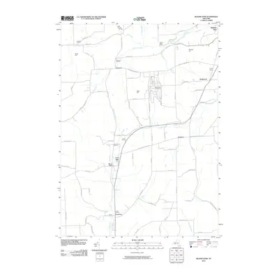
2010 Map of Beaver Dams
USGS Topo · Published 2010About this map
Beaver Dams and the surrounding rural landscape of Schuyler County are defined by a network of creeks and high ground in this 2010 survey. The topography is shaped by significant heights like Sugar Hill, Watkins Hill, and Baker Hill, with Watkins Glen International occupying a prominent position near the center of the map. This era of the landscape shows a mix of small hamlets and extensive family-named landmarks, such as Tilden Airport and a high density of local burial grounds including the Sugar Hill Cemetery and Quigley Cemetery.
Find a feature on this map
74 named features on this map. Tap any name to fly to it.
Don’t see what you’re looking for? This feature index may not catch every label — zoom into the map to look around manually.
Map Details
Editions of this 2010 Beaver Dams Map
This is the sole edition of this map. No revisions or reprints were ever made.
Other maps of this area

1895 · Elmira
USGS Topo · 1:62,500

1898 · Watkins Glen
USGS Topo · 1:62,500

1901 · Watkins
USGS Topo · 1:62,500

1903 · Hammondsport
USGS Topo · 1:62,500

1905 · Watkins Glen
USGS Topo · 1:125,000

1914 · Corning
USGS Topo · 1:62,500

1944 · Corning
USGS Topo · 1:62,500

1950 · Elmira
USGS Topo · 1:250,000
1950 · Burdett
USGS Topo · 1:24,000

1950 · Montour Falls
USGS Topo · 1:24,000