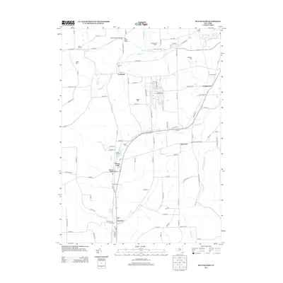
2013 Map of Beaver Dams
USGS Topo · Published 2013About this map
Watkins Glen International sits prominently on the ridge above Townsend, defining the modern landscape of this portion of Schuyler County. The settlement patterns follow the creek valleys, with Beaver Dams and Chambers situated along the path of Post Cr, while Moreland lies further east. Genealogists can find numerous burial grounds scattered across the terrain, including Sugar Hill Cem, Townsend Cem, and the Quigley Cem near the southern border. The map details a network of rural routes and family-named roads such as Vanzandt Hollow Rd and Meads Hill Rd, reflecting a landscape deeply rooted in its geographic hollows and hills. Aviation history is represented by Tilden Airport near Wedgewood, while natural features like Shequaga Cr and Hemlock Run drain the elevated heights of Baker Hill and Watkins Hill.
Find a feature on this map
102 named features on this map. Tap any name to fly to it.
Don’t see what you’re looking for? This feature index may not catch every label — zoom into the map to look around manually.
Map Details
Editions of this 2013 Beaver Dams Map
This is the sole edition of this map. No revisions or reprints were ever made.
Other maps of this area

1895 · Elmira
USGS Topo · 1:62,500

1898 · Watkins Glen
USGS Topo · 1:62,500

1901 · Watkins
USGS Topo · 1:62,500

1903 · Hammondsport
USGS Topo · 1:62,500

1905 · Watkins Glen
USGS Topo · 1:125,000

1914 · Corning
USGS Topo · 1:62,500

1944 · Corning
USGS Topo · 1:62,500

1950 · Elmira
USGS Topo · 1:250,000
1950 · Burdett
USGS Topo · 1:24,000

1950 · Montour Falls
USGS Topo · 1:24,000