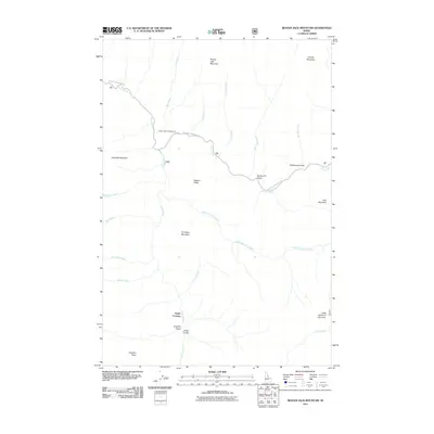
2011 Map of Beaver Jack Mountain
USGS Topo · Published 2011About this map
The Selway River cuts through this high mountain corridor, serving as the central drainage for a series of drainages including Test Creek, Cactus Creek, and Hells Half Acre Creek. The landscape is defined by its topographic extremes, anchored by Beaver Jack Mountain and the distinctive promontory of Old Warriors Face. Human presence is concentrated along the Magruder Corridor Rd, which provides access to the Deep Creek Campground and the remote settlement area at Upper Crossing. This region is shaped by steep drainages like Langdon Gulch and Grass Gulch, reflecting a wilderness character where travel is largely dictated by the river valley and the few established mountain roads. The naming of features like Horsejaw Mountain and Gold Pan Creek hints at the historic intersection of pack travel and early resource exploration in this section of Idaho County.
Find a feature on this map
29 named features on this map. Tap any name to fly to it.
Don’t see what you’re looking for? This feature index may not catch every label — zoom into the map to look around manually.
Map Details
Editions of this 2011 Beaver Jack Mountain Map
This is the sole edition of this map. No revisions or reprints were ever made.
Other maps of this area

1956 · Elk City
USGS Topo · 1:250,000

1960 · Elk City
USGS Topo · 1:250,000

1962 · Wood Hump
USGS Topo · 1:24,000

1962 · Beaver Jack Mtn
USGS Topo · 1:24,000

1962 · Blue Joint
USGS Topo · 1:24,000

1962 · Nez Perce Peak
USGS Topo · 1:24,000

1966 · Watchtower Peak
USGS Topo · 1:24,000

1966 · Spot Mountain
USGS Topo · 1:24,000
1966 · Burnt Strip Mtn
USGS Topo · 1:24,000

1978 · Magruder Mtn
USGS Topo · 1:24,000