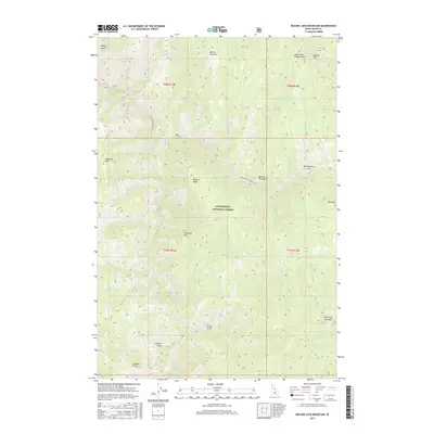
2017 Map of Beaver Jack Mountain
USGS Topo · Published 2017About this map
The Bitterroot National Forest dominates this interior Idaho landscape, where the Selway River cuts through the western reaches of the quadrangle. The terrain is defined by a series of high peaks and ridges including Beaver Jack Mtn, Horsejaw Mtn, and the distinctive Old Warriors Face. This mountainous area is largely primitive, though human activity is marked by the presence of the Magruder Corridor Rd and a historic extraction site at Borrow Pit Gulch. Numerous drainages such as Scimitar Cr, Deep Cr, and Hells Half-Acre Cr feed the larger river system. The map provides a look at the wilderness character of the region as documented by the 2017 U.S. Geological Survey, showing established landmarks like Langdon Point and the steep elevation of Cayuse Mtn.
Find a feature on this map
33 named features on this map. Tap any name to fly to it.
Don’t see what you’re looking for? This feature index may not catch every label — zoom into the map to look around manually.
Map Details
Editions of this 2017 Beaver Jack Mountain Map
This is the sole edition of this map. No revisions or reprints were ever made.
Other maps of this area

1956 · Elk City
USGS Topo · 1:250,000

1960 · Elk City
USGS Topo · 1:250,000

1962 · Wood Hump
USGS Topo · 1:24,000

1962 · Beaver Jack Mtn
USGS Topo · 1:24,000

1962 · Blue Joint
USGS Topo · 1:24,000

1962 · Nez Perce Peak
USGS Topo · 1:24,000

1966 · Watchtower Peak
USGS Topo · 1:24,000

1966 · Spot Mountain
USGS Topo · 1:24,000
1966 · Burnt Strip Mtn
USGS Topo · 1:24,000

1978 · Magruder Mtn
USGS Topo · 1:24,000