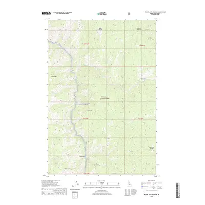
2020 Map of Beaver Jack Mountain
USGS Topo · Published 2020About this map
The Nez Perce Indian Trail winds through the high terrain of northeastern Idaho County, following a historic path across the Bitterroot National Forest. This 2020 survey documents a landscape dominated by complex drainage systems and prominent peaks, where the Middle Fork Clearwater Wild and Scenic River carves through the western edge of the quadrangle. Significant landmarks such as Beaver Jack Mtn and Horsejaw Mtn anchor the topography, while descriptive place names like Old Warriors Face and Hells Half Acre Mtn suggest the cultural and physical character of this mountain region. The network of waterways, including Test Cr and Lunch Cr, illustrates the intricate hydrology that feeds the Clearwater system, supporting a remote area defined by landforms like Pasture Ridge and Langdon Point.
Find a feature on this map
29 named features on this map. Tap any name to fly to it.
Don’t see what you’re looking for? This feature index may not catch every label — zoom into the map to look around manually.
Map Details
Editions of this 2020 Beaver Jack Mountain Map
This is the sole edition of this map. No revisions or reprints were ever made.
Other maps of this area

1956 · Elk City
USGS Topo · 1:250,000

1960 · Elk City
USGS Topo · 1:250,000

1962 · Wood Hump
USGS Topo · 1:24,000

1962 · Beaver Jack Mtn
USGS Topo · 1:24,000

1962 · Blue Joint
USGS Topo · 1:24,000

1962 · Nez Perce Peak
USGS Topo · 1:24,000

1966 · Watchtower Peak
USGS Topo · 1:24,000

1966 · Spot Mountain
USGS Topo · 1:24,000
1966 · Burnt Strip Mtn
USGS Topo · 1:24,000

1978 · Magruder Mtn
USGS Topo · 1:24,000