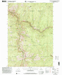
1998 Map of Beaver Jack Mountain
USGS Topo · Published 2002About this map
The Old Nez Perce Indian Trail winds across the high ridges of Idaho County, marking a corridor of travel that predates modern statehood. This 1998 revision by the Forest Service illustrates a landscape defined by the intersection of three major protected areas: the Selway Bitterroot Wilderness, the Bitterroot National Forest, and the Frank Church River of No Return Wilderness. At the heart of this terrain, the Middle Fork Clearwater River and the Selway River carve deep drainages through the mountains, joined by numerous seasonal tributaries like Sheep Gulch and Test Creek. Human presence is minimal, anchored by the Magruder Wood Center and the high-altitude Hells Half Acre Mountain Lookout. Steep terrain rises from the riverbanks to named peaks such as Beaver Jack Mountain, Horsejaw Mountain, and Haystack Mountain, while Langdon Point and Pasture Ridge offer significant vantage points over the river system.
Find a feature on this map
37 named features on this map. Tap any name to fly to it.
Don’t see what you’re looking for? This feature index may not catch every label — zoom into the map to look around manually.
Map Details
Editions of this 1998 Beaver Jack Mountain Map
This is the sole edition of this map. No revisions or reprints were ever made.
Other maps of this area

1956 · Elk City
USGS Topo · 1:250,000

1960 · Elk City
USGS Topo · 1:250,000

1962 · Wood Hump
USGS Topo · 1:24,000

1962 · Beaver Jack Mtn
USGS Topo · 1:24,000

1962 · Blue Joint
USGS Topo · 1:24,000

1962 · Nez Perce Peak
USGS Topo · 1:24,000

1966 · Watchtower Peak
USGS Topo · 1:24,000

1966 · Spot Mountain
USGS Topo · 1:24,000
1966 · Burnt Strip Mtn
USGS Topo · 1:24,000

1978 · Magruder Mtn
USGS Topo · 1:24,000