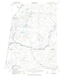
1955 Map of Beaver Pond
USGS Topo · Published 1961About this map
The Canada United States border defines the character of this remote timberland, where the Northwest Branch St John River and Southwest Branch St John River converge. Settlement is concentrated along the international boundary at Lac Frontiere and Daaquam, the latter featuring a Customs Office to manage cross-border traffic. The landscape is a complex network of glacial ponds and streams, including Presley Lake, Burntland Pond, and the drainage of Depot Stream.
Find a feature on this map
35 named features on this map. Tap any name to fly to it.
Don’t see what you’re looking for? This feature index may not catch every label — zoom into the map to look around manually.
Map Details
Editions of this 1955 Beaver Pond Map
3 editions found
Other maps of this area

1954 · Baker Lake
USGS Topo · 1:62,500

1954 · Allagash Lake
USGS Topo · 1:62,500

1954 · Presque Isle
USGS Topo · 1:250,000

1955 · Depot Lake
USGS Topo · 1:62,500

1955 · Beaver Pond
USGS Topo · 1:62,500

1955 · Clayton Lake
USGS Topo · 1:62,500

1955 · Seven Islands
USGS Topo · 1:62,500

1957 · Hardwood Mountain
USGS Topo · 1:62,500

1958 · Presque Isle
USGS Topo · 1:250,000

1960 · Presque Isle
USGS Topo · 1:250,000