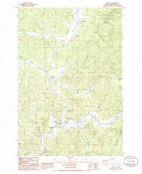
1985 Map of Beaver
USGS Topo · Published 1985About this map
The Nestucca River snakes through the southern portion of this mid-1980s survey, marking a landscape where coastal valley agriculture meets the timbered foothills of the Oregon Coast Range. The small settlement of Beaver serves as a local hub near the confluence of Beaver Creek and the river, while the community of Hemlock sits further north along the path of U.S. Route 101. The map documents a rugged transition between the Tillamook State Forest and the Siuslaw Nat For, illustrating how early transportation routes followed the winding watercourses of Tillamook River and Mills Creek. Local landmarks like the Cem and Munson Creek Falls Co Park provide specific points of interest for genealogists and local historians. The presence of a Quarry and various Borrow Pits reflects the area's ongoing reliance on natural resource extraction and infrastructure maintenance during this era.
Find a feature on this map
43 named features on this map. Tap any name to fly to it.
Don’t see what you’re looking for? This feature index may not catch every label — zoom into the map to look around manually.
Map Details
Editions of this 1985 Beaver Map
This is the sole edition of this map. No revisions or reprints were ever made.
Other maps of this area

1941 · Nestucca Bay
USGS Topo · 1:62,500

1942 · Ginger Peak
USGS Topo · 1:62,500

1942 · Spirit Mtn
USGS Topo · 1:62,500

1942 · Nestucca Bay
USGS Topo · 1:62,500

1942 · Tillamook
USGS Topo · 1:62,500

1948 · Vancouver
USGS Topo · 1:250,000

1950 · Vancouver
USGS Topo · 1:250,000

1950 · Vancouver
USGS Topo · 1:250,000

1955 · Hebo
USGS Topo · 1:62,500

1955 · Blaine
USGS Topo · 1:62,500