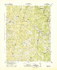
1943 Map of Beaverdam
USGS Topo · Published 1943About this map
The Chesapeake and Ohio railroad corridor anchors this mid-century landscape, linking the rural communities of Beaverdam, Tylers, and Bumpass. As the line moves through the territory of Hanover, Louisa, and Spotsylvania counties, it passes several small timber operations, each simply marked as Sawmill, suggesting the importance of local forestry to the regional economy. The settlement pattern is defined by crossroad landmarks like Greenes Corner and general mercantile locations such as Harris Store and Terrell Store.
Find a feature on this map
23 named features on this map. Tap any name to fly to it.
Don’t see what you’re looking for? This feature index may not catch every label — zoom into the map to look around manually.
Map Details
Editions of this 1943 Beaverdam Map
This is the sole edition of this map. No revisions or reprints were ever made.
Other maps of this area

1887 · Spottsylvania
USGS Topo · 1:125,000

1890 · Goochland
USGS Topo · 1:125,000

1892 · Spottsylvania
USGS Topo · 1:125,000

1892 · Goochland
USGS Topo · 1:125,000

1942 · Ladysmith
USGS Topo · 1:31,680

1942 · Partlow
USGS Topo · 1:31,680

1942 · Contrary Creek
USGS Topo · 1:31,680

1942 · Buckner
USGS Topo · 1:24,000

1942 · Beaverdam
USGS Topo · 1:24,000

1943 · Mabelton
USGS Topo · 1:31,680