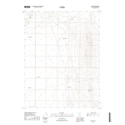
2018 Map of Beck Pass
USGS Topo · Published 2018About this map
Beck Pass serves as the topographic high point in this 2018 survey, marking the transition between the northern heights of the Ruby Mountains and the southern White Pine Range. The map illustrates a classic Great Basin landscape where the broad, flat expanse of the Newark Valley meets these prominent north-south mountain corridors. The terrain is characterized by dramatic elevation shifts, moving from the valley floor up the steep slopes of Dry Mtn, providing a clear look at the geological boundaries of White Pine County. While the map is sparse of modern settlements, it documents the enduring topographical features that have historically dictated travel routes and land use throughout this portion of eastern Nevada.
Find a feature on this map
9 named features on this map. Tap any name to fly to it.
Don’t see what you’re looking for? This feature index may not catch every label — zoom into the map to look around manually.
Map Details
Editions of this 2018 Beck Pass Map
This is the sole edition of this map. No revisions or reprints were ever made.
Other maps of this area

1951 · Illipah
USGS Topo · 1:62,500

1951 · Pancake Summit
USGS Topo · 1:62,500

1956 · Ely
USGS Topo · 1:250,000

1957 · Buck Mountain
USGS Topo · 1:62,500

1959 · Ely
USGS Topo · 1:250,000

1963 · Ely
USGS Topo · 1:250,000

1979 · Mt. Hamilton
USGS Topo · 1:100,000

1982 · Sunshine Well
USGS Topo · 1:24,000
1982 · Sunshine Well NW
USGS Topo · 1:24,000

1985 · Newark Lake
USGS Topo · 1:100,000