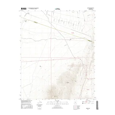
2017 Map of Becker
USGS Topo · Published 2017About this map
The settlement of Becker sits at the northern edge of this high-desert landscape where the border of Valencia and Socorro Counties bisects the terrain. This modern survey illustrates a region defined by dramatic elevation changes, from the alluvial plains around Abo Arroyo and Goat Draw to the steep eastern slopes of the Los Pinos Mountains. Notable landmarks include the Burris Ranch Number 1 Airport in the northwest and Whiteface Mtn rising in the south. The map details a unique residential grid of winding roads and circles, such as Tierra Grande Loop and Tonada Loop, which contrast with the natural drainage patterns of Pino Draw and the isolated Blue Spring. This geography provides a clear record of 21st-century land division in a region historically shaped by rugged topography and limited water sources.
Find a feature on this map
29 named features on this map. Tap any name to fly to it.
Don’t see what you’re looking for? This feature index may not catch every label — zoom into the map to look around manually.
Map Details
Editions of this 2017 Becker Map
This is the sole edition of this map. No revisions or reprints were ever made.
Other maps of this area

1916 · La Joya
USGS Topo · 1:125,000

1917 · Estancia
USGS Topo · 1:125,000

1952 · Tome SE
USGS Topo · 1:24,000

1952 · Black Butte
USGS Topo · 1:24,000

1952 · Turn
USGS Topo · 1:24,000

1952 · Becker SW
USGS Topo · 1:24,000

1952 · Becker
USGS Topo · 1:24,000

1952 · Cerro Montoso
USGS Topo · 1:24,000

1954 · Torreon
USGS Topo · 1:62,500

1954 · Socorro
USGS Topo · 1:250,000