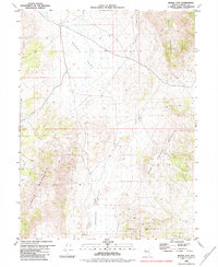
1980 Map of Bedell Flat
USGS Topo · Published 1984About this map
Bedell Flat forms the central basin of this high-desert Nevada landscape, surrounded by a complex network of mountain ranges including Dogskin Mountain to the east and Freds Mountain to the west. This 1980s topography, based on data from the mid-1970s, illustrates a sparsely settled region defined by its geology and mineral potential rather than urban development. Traces of human activity are concentrated around resource extraction and communication, visible in several prospects and a mine located on the slopes of Hungry Mountain. The presence of a Radio Facility on Warm Springs Mountain and a solitary well in Antelope Valley suggests the infrastructure required to manage and monitor this remote terrain. A network of jeep trails provides the primary access through the Sand Hills, connecting the valley floors to the surrounding peaks.
Find a feature on this map
15 named features on this map. Tap any name to fly to it.
Don’t see what you’re looking for? This feature index may not catch every label — zoom into the map to look around manually.
Map Details
Editions of this 1980 Bedell Flat Map
2 editions found
Other maps of this area

1891 · Reno
USGS Topo · 1:125,000

1893 · Reno
USGS Topo · 1:125,000

1950 · Reno
USGS Topo · 1:62,500

1951 · Reno
USGS Topo · 1:62,500

1957 · Sutcliffe
USGS Topo · 1:62,500

1957 · Dogskin Mountain
USGS Topo · 1:62,500

1957 · Spanish Springs Valley
USGS Topo · 1:62,500

1957 · Reno
USGS Topo · 1:250,000

1959 · Reno
USGS Topo · 1:250,000

1960 · Reno
USGS Topo · 1:250,000