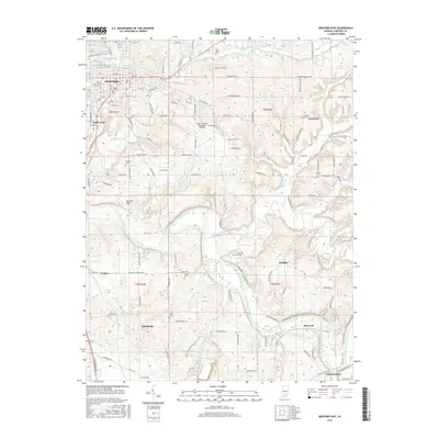
2016 Map of Bedford East
USGS Topo · Published 2016About this map
Bedford and the wide Mitchell Plain anchor the northwestern portion of this Lawrence County landscape, where the urban grid gives way to a complex system of karst topography and river valleys. The East Fork White River meanders through the southern half of the quadrangle, joined by tributaries such as Guthrie Creek, Leatherwood Creek, and Rock Lick Br. This river network historically dictated the placement of small rural communities like Rivervale, Buddha, and Lawrenceport, which sit among the undulating terrain of t4n r1e and t5n r1e. Local history is deeply etched into the land through numerous family and community burial grounds, including Beech Grove Cem and Green Hill Cem near the city, and more remote sites like Ikerd Cem and Starr Cem. The presence of the Virgil I Grissom Municipal Airport and Cement Plant Rd reflects the integration of modern transportation and industry within this traditional limestone-quarrying region.
Find a feature on this map
99 named features on this map. Tap any name to fly to it.
Don’t see what you’re looking for? This feature index may not catch every label — zoom into the map to look around manually.
Map Details
Editions of this 2016 Bedford East Map
This is the sole edition of this map. No revisions or reprints were ever made.
Other maps of this area

1934 · Bedford
USGS Topo · 1:48,000

1935 · Oolitic
USGS Topo · 1:48,000

1937 · Bedford
USGS Topo · 1:62,500

1942 · Oolitic
USGS Topo · 1:62,500

1949 · Georgia
USGS Topo · 1:24,000

1950 · Mitchell
USGS Topo · 1:24,000

1951 · Georgia
USGS Topo · 1:24,000

1956 · Vincennes
USGS Topo · 1:250,000

1957 · Vincennes
USGS Topo · 1:250,000
1957 · Oolitic
USGS Topo · 1:24,000