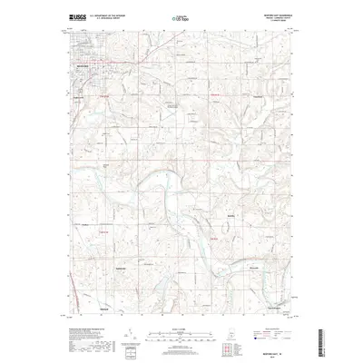
2019 Map of Bedford East
USGS Topo · Published 2019About this map
Bedford serves as the northern anchor for this landscape, where the urban street grid gives way to the karst topography of the Mitchell Plain. The southern portion of the map is defined by the winding course of the East Fork White River, which carves through the terrain near Lawrenceport and Rivervale. This river system and its tributaries, including Guthrie Creek and Leatherwood Creek, dictated the early placement of rural settlements and transport routes.
Find a feature on this map
94 named features on this map. Tap any name to fly to it.
Don’t see what you’re looking for? This feature index may not catch every label — zoom into the map to look around manually.
Map Details
Editions of this 2019 Bedford East Map
This is the sole edition of this map. No revisions or reprints were ever made.
Other maps of this area

1934 · Bedford
USGS Topo · 1:48,000

1935 · Oolitic
USGS Topo · 1:48,000

1937 · Bedford
USGS Topo · 1:62,500

1942 · Oolitic
USGS Topo · 1:62,500

1949 · Georgia
USGS Topo · 1:24,000

1950 · Mitchell
USGS Topo · 1:24,000

1951 · Georgia
USGS Topo · 1:24,000

1956 · Vincennes
USGS Topo · 1:250,000

1957 · Vincennes
USGS Topo · 1:250,000
1957 · Oolitic
USGS Topo · 1:24,000