1937 Map of Bedford
USGS Topo · Published 1937About this map
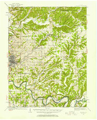
Bedford serves as the industrial and transportation anchor for this central Lawrence County landscape, defined by a dense network of limestone production and rail logistics. Extensive operations at Fanning Quarry, Peerless Quarry, and Lehigh Quarry highlight the region's mineral wealth, while the Chicago Milwaukee St Paul and Pacific railroad carves a winding path through the limestone hills. To the south, the East Fork White River loops through narrow valleys past rural outposts like Tunnelton and Fort Ritner. This 1930s survey reveals a deeply settled backcountry where small communities such as Heltonville and Leesville are connected by a web of country schools and churches, including Henderson Sch and Dixon Chapel. The mapping shows the transition from the structured street grid of the county seat to the meandering drainage of Guthrie Creek and Leatherwood Creek.
Find a feature on this map
54 named features on this map. Tap any name to fly to it.
Don’t see what you’re looking for? This feature index may not catch every label — zoom into the map to look around manually.
Map Details
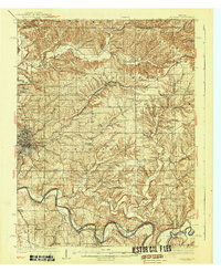
Editions of this 1937 Bedford Map
2 editions found
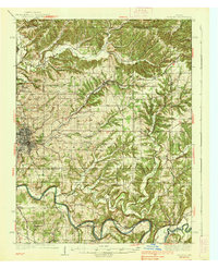
Historical Maps of Bedford Through Time
4 maps found