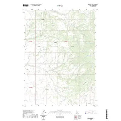
2023 Map of Bedstead Ridge
USGS Topo · Published 2023About this map
The Middle Fork Owyhee River cuts through this high desert plateau, creating a complex drainage network defined by deep gulches and prominent volcanic features. This 2023 survey of the Bedstead Ridge area reveals a landscape oriented around scarce water sources and seasonal grazing flats like Manada Flat, Horse Flat, and Stauffer Flat. Named springs such as Fenwick Spring, Cottonwood Spring, and Twin Springs serve as vital landmarks in an area dominated by significant terrain features including Juniper Mtn and the distinct formation known as The Buttes. The mapping of remote cattle-working areas like Herds V and Bull Basin provides geographic context for the region's enduring ranching history and land management patterns within Owyhee County.
Find a feature on this map
50 named features on this map. Tap any name to fly to it.
Don’t see what you’re looking for? This feature index may not catch every label — zoom into the map to look around manually.
Map Details
Editions of this 2023 Bedstead Ridge Map
This is the sole edition of this map. No revisions or reprints were ever made.
Other maps of this area

1955 · Jordan Valley
USGS Topo · 1:250,000

1957 · Jordan Valley
USGS Topo · 1:250,000

1958 · Jordan Valley
USGS Topo · 1:250,000

1973 · Red Basin
USGS Topo · 1:24,000

1973 · Smith Creek
USGS Topo · 1:24,000

1973 · Bedstead Ridge
USGS Topo · 1:24,000

1973 · Pleasant Valley
USGS Topo · 1:24,000

1973 · Fairylawn
USGS Topo · 1:24,000
1977 · Bull Basin Camp
USGS Topo · 1:24,000

1980 · Brewster Reservoir
USGS Topo · 1:24,000