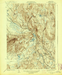
1942 Map of Belchertown
USGS Topo · Published 1942About this map
Belchertown serves as the focal point for this pre-war landscape, where the Central Vermont and Boston and Maine railroads converge. The map illustrates a complex network of early Massachusetts transit, including a section of Abandoned Central Vermont rail passing through Dwight. The institutional history of the area is well-represented, anchored by the expansive grounds of the State School and the St Hyacinths Seminary near the Granby border. Small, concentrated residential pockets like Cooks Corner, Meads Corner, and Knights Corner appear as traditional rural crossroads before modern suburban development. To the west, the swampy lowlands of Lawrence Swamp and Station Brook contrast with the higher elevations of Mt Lincoln and Junker Hill, showing the varied topography that dictated the placement of early cemeteries such as Munsel Cem and Lake Vale Cem.
Find a feature on this map
69 named features on this map. Tap any name to fly to it.
Don’t see what you’re looking for? This feature index may not catch every label — zoom into the map to look around manually.
Map Details
Editions of this 1942 Belchertown Map
This is the sole edition of this map. No revisions or reprints were ever made.
Other maps of this area

1885 · Northampton
USGS Topo · 1:62,500

1886 · Springfield
USGS Topo · 1:62,500

1886 · Northampton
USGS Topo · 1:62,500

1887 · Palmer
USGS Topo · 1:62,500

1887 · Belchertown
USGS Topo · 1:62,500

1889 · Springfield
USGS Topo · 1:62,500

1889 · Palmer
USGS Topo · 1:62,500

1890 · Belchertown
USGS Topo · 1:62,500

1891 · Northampton
USGS Topo · 1:62,500

1893 · Northampton
USGS Topo · 1:62,500