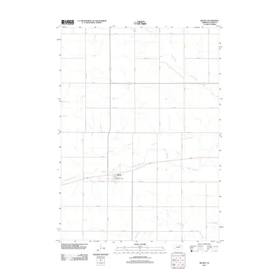
2011 Map of Belden
USGS Topo · Published 2011About this map
Belden serves as the central hub of this Cedar County landscape, which is defined by a rigorous grid of section-line roads and the winding paths of several prairie waterways. The village is anchored by the Belden Post Office, situated at the intersection of a local highway and the north-south grid. The terrain is deeply carved by the drainage patterns of Middle Logan Creek, which meanders roughly east-west through the center of the sheet. Further north, the landscape is fed by Perrin Creek, while Baker Creek flows through the southern reaches. This 2011 survey reflects the enduring character of Nebraska's agricultural infrastructure, where the precise network of numbered avenues and roads, such as 870th Rd and 567 Ave, provides the primary structure for land management and travel between homesteads.
Find a feature on this map
22 named features on this map. Tap any name to fly to it.
Don’t see what you’re looking for? This feature index may not catch every label — zoom into the map to look around manually.
Map Details
Editions of this 2011 Belden Map
This is the sole edition of this map. No revisions or reprints were ever made.
Other maps of this area

1955 · Sioux City
USGS Topo · 1:250,000

1958 · Sioux City
USGS Topo · 1:250,000

1959 · Sioux City
USGS Topo · 1:250,000

1968 · Coleridge
USGS Topo · 1:24,000

1968 · Hartington
USGS Topo · 1:24,000
1968 · Coleridge SE
USGS Topo · 1:24,000
1971 · Laurel
USGS Topo · 1:24,000

1971 · Belden
USGS Topo · 1:24,000

1971 · Randolph South
USGS Topo · 1:24,000

1971 · Randolph North
USGS Topo · 1:24,000