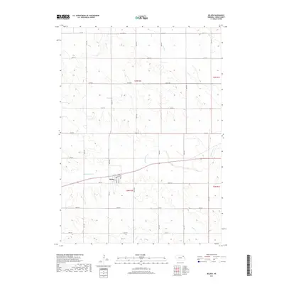
2017 Map of Belden
USGS Topo · Published 2017About this map
Belden serves as the primary hub of this Cedar County landscape, situated where the terrain begins to slope toward the valley of Middle Logan Cr. The village is organized along a traditional grid, featuring named thoroughfares such as Nebraska St, Cedar St, and Dodge St. This 2017 survey illustrates the persistent agricultural character of northeast Nebraska, where section lines are strictly followed by a network of rural roads like 874th Rd and 565th Ave. The drainage patterns of Baker Cr and Perrin Cr carve distinct coulees through the high plains, providing a topographical contrast to the straightened survey lines that define the property boundaries across Townships 28 and 29 North. Local historians can use these precise coordinates to locate specific farmsteads and rural intersections at the start of the 21st century.
Find a feature on this map
28 named features on this map. Tap any name to fly to it.
Don’t see what you’re looking for? This feature index may not catch every label — zoom into the map to look around manually.
Map Details
Editions of this 2017 Belden Map
This is the sole edition of this map. No revisions or reprints were ever made.
Other maps of this area

1955 · Sioux City
USGS Topo · 1:250,000

1958 · Sioux City
USGS Topo · 1:250,000

1959 · Sioux City
USGS Topo · 1:250,000

1968 · Coleridge
USGS Topo · 1:24,000

1968 · Hartington
USGS Topo · 1:24,000
1968 · Coleridge SE
USGS Topo · 1:24,000
1971 · Laurel
USGS Topo · 1:24,000

1971 · Belden
USGS Topo · 1:24,000

1971 · Randolph South
USGS Topo · 1:24,000

1971 · Randolph North
USGS Topo · 1:24,000