1978 Map of Belfry
USGS Topo · Published 1978About this map
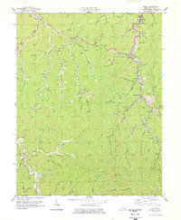
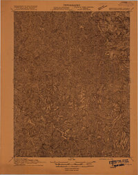
Belfry and the surrounding coalfields of Pike County appear here at a time of intensive resource extraction and established mountain settlements. The landscape is defined by the winding paths of Pond Fork and Johns Creek, which dictate the placement of communities like Stone, McVeigh, and Sharondale. The heavy industrial footprint of the era is evident through numerous strip mines and the Norfolk and Western rail lines that thread through the narrow hollows to reach them. Local family history is preserved in small burial grounds such as the Smith Cem and Stump Cem, while the Belfry High Sch serves as a central landmark for the northern valley. From the heights of Canada Knob to the technical facilities at Peg Sta, this map illustrates the infrastructure required to support a rugged extraction-based economy in the late 1970s.
Find a feature on this map
64 named features on this map. Tap any name to fly to it.
Don’t see what you’re looking for? This feature index may not catch every label — zoom into the map to look around manually.
Map Details
Editions of this 1978 Belfry Map
This is the sole edition of this map. No revisions or reprints were ever made.
Other maps of this area

1886 · Grundy
USGS Topo · 1:125,000

1887 · Warfield
USGS Topo · 1:125,000

1890 · Grundy
USGS Topo · 1:125,000

1891 · Warfield
USGS Topo · 1:125,000

1892 · Grundy
USGS Topo · 1:125,000
1909 · Matewan
USGS Topo · 1:48,000

1914 · Hurley
USGS Topo · 1:48,000
1915 · Regina
USGS Topo · 1:48,000
1915 · Hurley
USGS Topo · 1:48,000
1915 · Williamson
USGS Topo · 1:48,000