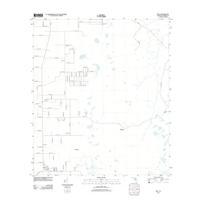
2012 Map of Bell
USGS Topo · Published 2012About this map
The town of Bell serves as the focal point for this north-central Florida survey, where the street grid of Rodeo Ave and Co Hwy-236 meets the surrounding agrarian landscape. The area is characterized by a high concentration of ephemeral wetlands and water bodies, including the unusually named Poley Cow Pen, Half Moon Pond, and Sevenmile Lake. These features, alongside Smiths Prairie, illustrate the unique hydrology of Gilchrist County.
Find a feature on this map
56 named features on this map. Tap any name to fly to it.
Don’t see what you’re looking for? This feature index may not catch every label — zoom into the map to look around manually.
Map Details
Editions of this 2012 Bell Map
This is the sole edition of this map. No revisions or reprints were ever made.
Other maps of this area

1954 · Gainesville
USGS Topo · 1:250,000

1958 · Gainesville
USGS Topo · 1:250,000

1959 · Gainesville
USGS Topo · 1:250,000

1968 · Waters Lake
USGS Topo · 1:24,000

1968 · Fourmile Lake
USGS Topo · 1:24,000

1968 · Branford
USGS Topo · 1:24,000

1968 · Hatchbend
USGS Topo · 1:24,000
1968 · Hildreth
USGS Topo · 1:24,000
1968 · Wannee
USGS Topo · 1:24,000
1968 · Bell
USGS Topo · 1:24,000