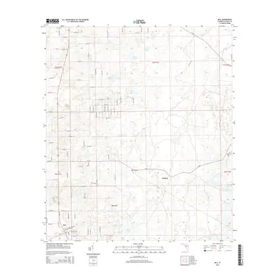
2015 Map of Bell
USGS Topo · Published 2015About this map
The town of Bell anchors this Gilchrist County landscape, situated near the intersection of CR-340 and Rodeo Ave. The surrounding area is characterized by a high density of named ponds and low-lying prairies, which dictate the sparse, grid-like road network. To the east and north of the main settlement lie the localities of Harvard and Williford, while the remote Mount Horeb Cem serves as a significant genealogical marker near Cow Cr. Numerous water bodies such as Sevenmile Lake, Half Moon Pond, and Bone Pond dot the terrain, interspersed with distinctive local features like Smiths Prairie and Poley Cow Pen. The infrastructure is largely composed of unpaved and secondary routes, including E Railroad Ave, indicating a rural character shaped by both natural drainage patterns and the historic rail alignment that once passed through Bell.
Find a feature on this map
60 named features on this map. Tap any name to fly to it.
Don’t see what you’re looking for? This feature index may not catch every label — zoom into the map to look around manually.
Map Details
Editions of this 2015 Bell Map
This is the sole edition of this map. No revisions or reprints were ever made.
Other maps of this area

1954 · Gainesville
USGS Topo · 1:250,000

1958 · Gainesville
USGS Topo · 1:250,000

1959 · Gainesville
USGS Topo · 1:250,000

1968 · Waters Lake
USGS Topo · 1:24,000

1968 · Fourmile Lake
USGS Topo · 1:24,000

1968 · Branford
USGS Topo · 1:24,000

1968 · Hatchbend
USGS Topo · 1:24,000
1968 · Hildreth
USGS Topo · 1:24,000
1968 · Wannee
USGS Topo · 1:24,000
1968 · Bell
USGS Topo · 1:24,000