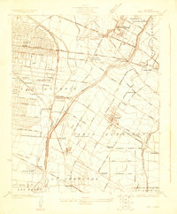
1923 Map of Bell
USGS Topo · Published 1923About this map
Los Angeles River and Rio Hondo define the landscape of this region during a period of rapid development and agricultural transition. The map records a dense network of early suburban gridiron streets in Maywood and Bell, contrasting with the more open acreage of the County Farm and the scattered ranchos of Santa Gertrudes. The influence of the nascent petroleum industry is evidenced by the Rio Grande Oil Co facilities near Vinevale.
Find a feature on this map
70 named features on this map. Tap any name to fly to it.
Don’t see what you’re looking for? This feature index may not catch every label — zoom into the map to look around manually.
Map Details
Editions of this 1923 Bell Map
This is the sole edition of this map. No revisions or reprints were ever made.
Other maps of this area

1894 · Los Angeles
USGS Topo · 1:62,500

1896 · Pasadena
USGS Topo · 1:62,500

1896 · Downey
USGS Topo · 1:62,500

1899 · Downey
USGS Topo · 1:62,500

1900 · Pasadena
USGS Topo · 1:62,500

1900 · Los Angeles
USGS Topo · 1:62,500

1901 · Southern California Sheet No. 1
USGS Topo · 1:250,000

1902 · Downey
USGS Topo · 1:62,500

1904 · Southern California Sheet No. 1
USGS Topo · 1:250,000
1923 · El Monte
USGS Topo · 1:24,000